Showing posts with label GNSS. Show all posts

Thursday, 26 October 2023

Reactions in Singapore to ERP 2.0

Following the announcement of the roll-out of ERP 2.0 in Singapore (using GNSS-based On Board Units for congestion pricing), there has been some comment in the media in Singapore about the new system and policy around it. Some of this is likely to be relevant to other jurisdictions considering mandating such technology into motor vehicles.

What do motorists and car dealers think?

The Straits Times published an article on 25 October by Lee Nian Tjoe on what motorists and car dealers think.

Dealerships generally said that they were ready for the rollout, as some had been establishing how to conceal wiring and have the equipment installed in their vehicles, but some still were awaiting information...

Ms Tracy Teo, marketing director of Komoco Motors, which represents Hyundai, Jeep, Ferrari, Maserati and Alfa Romeo in Singapore, said the company is awaiting information and instruction from LTA on the next steps.

One of the key issues is that getting such equipment installed in a wide variety of makes and models may present challenges for some varieties of vehicles. 

Comments from members of the public approached by the journalist were largely questioning with some concerns, such as the location of the OBU on the side of the passenger footwell.  One objected to the system having capability to have stored value cards inserted given how technology had moved beyond that. 

The article describes how a fleet operator was used to test installation of 500 devices in a pilot.

Should it have been rolled out in the first place?

A second article from the website Techgoondu is critical of the new system.

Author Alfred Siew describes it as:

the unwanted rollout of a costly project that has taken nearly 20 years to complete, if you count its early efforts. It is clearly outdated and inconvenient for users. Many questions have already been raised about this “next-gen” ERP 2.0 unit when it was unveiled two years ago. Most damning was why it was even necessary.

Part of this is unfair, as it is not a 20 year long project, but it is certainly was being thought about 10 years ago. Singapore needed a new system because "ERP 1.0" was creaky and obsolete, and needed replacement.  It would have been cheaper to go all ANPR (Automatic Number Plate Recognition) based, but certain features would not have been available, and it could have simply been an update of the current technology.  However, Siew notes correctly that the "next-generation" features around traffic information are largely available through apps such as Waze.  Smartphones are able to be used as the in-vehicle display is optional, so the question becomes what it would have taken to make smartphones work?  The key issues around reliability and linking it to the vehicle remain, but this is being trialled in Brussels now.

Siew describes the system as old technology, with the stored-value cards which are increasingly obsolete and an in-vehicle display reminiscent of pre-smartphone navigation systems.  Of course many cars have automaker installed telematics with some key elements of the ERP 2.0 system included, although not available for congestion pricing applications. Making Original Equipment Manufacturer (OEM) telematics systems available and suitable for road pricing is perhaps the "rosetta stone" for ubiquitous road pricing in the future.  Unfortunately efforts to do this so far have been very limited across the globe.

Siew finally criticises it for being a system with the capability to introduce distance based charging, but that capability is not to be used as of yet.  That doesn't mean that it won't  be and it is entirely understandable that a policy decision to do that would not be announced until the entire system is installed and proven, but unless it is used, it seems like an expensive solution to what is just an effort to replace an old system with one with less intrusive roadside infrastructure.

Of course LTA had signed the contract for the ERP 2.0 system some years ago and became committed to the project, so it had to be rolled out.  Hopefully it will all prove to be worthwhile and operate successfully for many years to come.

Distance-based pricing is unlikely anytime soon

Newspaper Today online published an article by Loraine Lee on 25 October saying that it was unlikely LTA would implement distance based pricing soon.

Key issues identified were:

  • How to apply it equitably, including the future of fuel taxes and vehicle registration/ownership taxes, so that those that travel the most are not paying disproportionately compared to what they do now.  
  • Questions over the location accuracy of the technology in parts of Singapore with tall building, and with tunnels (the latter is not a real issue, as systems elsewhere can clearly note when vehicles travelling on a road disappear and reappear at another location, that they must have been in the tunnel on that route). 
  • Need to consider the wider impacts of a shift towards distance-based charging on some road users.
The accuracy issues can certainly be addressed, as they have been in other GNSS-based road user charging systems in Europe, the United States and New Zealand, but the policy issues about Singapore's mix of taxes require some further work to disaggregate.  Clearly fuel taxation will be eroding due to the emergence of electric and hybrid vehicles, and a shift from ownership based taxes to usage based taxes is likely to increase car ownership, but reduce distance travelled by car and congestion, so some modelling will be needed to forecast the impacts on Singapore's traffic (and vehicle fleet size).  

The key point is the new system will provide options, and it would be a poor use of the technology to not have some form of distance based charging or at the very least use it to implement more 'virtual gantries' for pricing.  

Time will tell whether other cities will copy Singapore technologically (they should copy parts of it in terms of pricing policy), my suspicion is that the inclusion of a slot for stored-payment cards is unlikely to be replicated, nor is a in-vehicle display, but the core of the technology still has merits.  The options for using GNSS-technology for congestion pricing are:
  • Purpose built OBUs for professional installation in vehicles
  • Scaled down "self-installed" OBUs
  • OEM telematics 
  • Smartphones
Singapore has chosen the first, we will see if the next GNSS-based congestion pricing system selects an alternative.

Wednesday, 29 April 2020

Australia: Industry briefing of National Heavy Vehicle Charging Pilot Large Scale On-Road Trial Procurement

The Australian (Federal) Government's Department of Infrastructure, Transport, Regional Development and Communications has published a Notification of Industry Briefing, for its National Heavy Vehicle Charging Pilot.  The industry briefing will be held THIS FRIDAY 1 May from 0815-1030 Australian Eastern Standard Time (2215-0030 UTC/GMT 30 April-1 May) and then 1715-1930 the same day (0715-0930 UTC/GMT 1 May).  The first session is timed for Australian, New Zealand and North/South American interest, and the second one for Asian, European/African interest.

The text below is a verbatim extract directly from the notice:

The purpose of this industry brief is to provide information to, and obtain information from, potential tenderers for three planned solutions procurements for the National Heavy Vehicle Charging Pilot’s Large Scale On-Road Trial.

    Provision of telematics devices and services
    Provision of third-party invoicing services
    Provision of manual collection devices and reporting services

This briefing is not a procurement and does not form part of any Commonwealth procurement process. The Commonwealth will not select or exclude (from future participation in above procurements) any companies based on their attendance or non-attendance at the Industry Brief.

Following the Industry Briefing sessions, there will be a period in which the department will accept feedback submissions from industry on the proposed technical approaches to gathering data and generating invoices and mock permits.

The National Heavy Vehicle Charging Pilot (National Pilot) is an innovative industry partnership testing potential direct road user charging options for heavy vehicles. The Large Scale On-Road trial is anticipated to involve up to 100 participants providing more than 1000 vehicles across diverse industries and fleet sizes.  

Trial Participants will test several operational models for collecting and reporting distance travelled. Existing and charging-specific telematics systems will be tested, as well as non-telematics distance measurement technology (hubodometers).

No money will be collected from trial participants. Instead, the data collected will be used to generate mock invoices. The mock invoice will be used to calculate and compare alternate mass-distance and location-based charges with an estimation of annual registration and fuel-based road user charges (current PAYGO model) collected for each participant. 

END

Further details on the National Heavy Vehicle Charging Pilot are found on the Department's website. 

Disclaimer: D'Artagnan Pacific is technical advisor to the Department of Infrastructure, Transport, Regional Development and Communications

Monday, 29 July 2019

Australia's National Heavy Vehicle Charging Pilot : Small-scale on-road trial of heavy vehicle charging is launched

Last Thursday (25 July 2019), Australia's Deputy Prime Minister and Minister for Transport, Infrastructure and Regional Development, The Hon. Michael McCormack along with The Hon Scott Buchholz MP, Assistant Minister for Road Safety and Freight Transport formally launched Australia's first nationwide on-road trial of heavy vehicle road user charging.

The press release is here, with more details on the Department of Infrastructure, Transport, Cities and Regional Development ("the Department") website here.

In short, it involves:
  • Up to eleven heavy vehicle operators (truck and bus) using on-board telematics systems that they were already using in their vehicles (commercial telematic systems used for fleet management purposes);
  • Up to 111 vehicles will be included (so an average of a maximum of ten vehicles per fleet);
  • A trial of six months duration;
  • Operators to use existing systems to report vehicle configuration;
  • Each operator will receive mock invoices generated by measurement of road use using the telematics systems on each participating vehicle, which will enable comparison of hypothetical charges with current charges
The trial will assess the experience of heavy vehicle users in receiving mock invoices to compare what they might pay under distance/mass/configuration based charging compared to the current mix of annual registration fees and fuel tax.  The idea being that charging by distance could replace such charges.  The diagram below from the Department indicates its plan to follow the small-scale trial with a large-scale trial next year on a much bigger scale and complexity. 

Australia's heavy vehicle charging trial programme
The small scale trial will use only one technology - existing telematics systems (which by necessity are all GNSS based On-Board Units (OBUs). The large scale trial could also include manual options to report distance, and an option to report actual mass.  However, further details of the large scale trial will be developed in the coming months, and is likely to be informed by the progress and evaluation of the small scale trial, and engagement with stakeholders (including heavy vehicle user representative organisations).

The operators participating in the small-scale trial are:
This is quite a range including local and national operators, with operators based in several states.  Telematics providers supporting the trial (providing the systems used by those operators) are:
The trials are part of a wider programme of reform of the provision of roads for heavy vehicles in Australia called Heavy Vehicle Road Reform.  The first phase of this is set out here, and involves improving transparency about spending, asset management and the levels of service provided to heavy vehicle road users. 

Other reforms as part of this include consideration of independent price regulation of the setting of heavy vehicle charges (including existing registration fees and the fuel-based charge), and measures to more closely link revenue collected from heavy vehicles to road managers for investment in their networks.

It is clear that it is early days and no decision has been made by the Australian Government to change how heavy vehicles are charged in Australia, and any decision to do so is likely to be some years away. 

It will be interesting to watch the small scale trial with interest, particularly what the responses of participants are and the lessons that the Department will learn from the trial to develop the larger scale trial and inform wider reforms. 

Disclosure:  D'Artagnan has been providing technical advice to the Department of Infrastructure, Transport, Cities and Regional Development on heavy vehicle charging trials.

Wednesday, 18 April 2018

Update on Germany's heavy (and light) vehicle charging systems

On 1 January 2005, Germany introduced the world's first full GNSS based road user charging system, applying only to trucks with a Gross Vehicle Weight (GVW) of 12 tonnes and above. Unlike the Swiss system (LSVA), which used GNSS technology to supplement the tachograph (primarily for verification and compliance purposes) as a means of measuring distance, the LKW-Maut (as the German system is called) uses an On Board Unit (OBU) with GNSS technology to map match to measure distance for chargeable purposes. A consortium known as Toll Collect won the PPP contract to finance, design, build and operate the system. 

From motorways to all highways

The system has expanded from the original network of around 12,500km of motorways by around 2,300km in recent years (mainly by adding segments of Federal highways that were used by trucks diverting from motorways to avoid charges), but will be expanded again on 1 July 2018 to ALL Federal highways. The charged network will then consist of over 40,000km of roads (see below)
Map of all Germany Federal Highways and Motorways
There are further discussions about expanding the scope of the system to include buses and coaches, and all vehicles with a GVW of at least 3.5 tonnes (which is the widely used definition of "heavy vehicles" in the European Union).   I expect that once the system has expanded to Federal Highways, there will be a need to further expand the chargeable network to include regional and local roads.

As part of the expansion to the whole Federal highway network, the process of charging trucks is to change.  At present, OBUs measure distance and calculate the charge applicable for the vehicle, then transmitting the charging data to the back office to bill the operator.  Charging rate table data is transmitted to each OBU as it is updated, so that all trip data is retained in the OBU.  All that is transmitted is data that a truck with a specific identity travelled X number of kilometres on charged highways over a set period of dates.   This is to change.  All trip data is to be transmitted to the back office, with the calculation of charges undertaken centrally, rather than on each OBU.

It is explained as follows by Toll Collect:

This is necessary because the very large route network will give rise to changes much more frequently in the future, especially on the federal trunk road – e.g. construction sites or traffic blockades. Therefore, route information that determines the toll calculations must be adjusted much quicker than before.

In other words, with some routes likely to be closed at some times (and trucks diverted onto alternative, longer routes), it will be easier to apply exceptions to the current system by calculating charges centrally, than by applying such temporary changes through updates to over 1.1 million vehicle OBUs. 

In the early days of discussions about GNSS OBU technology, options were discussed as to whether OBUs would be a "thick" client or a "thin" client.

A thick client would have all processing undertaken in the OBU, which would then only transmit the calculated charge data to the back office for billing purposes.  There are advantages in reducing communications costs, higher protection of privacy (due to a lack of trip data being transmitted) and reducing the risk of the system not being functional due to breakdown of the centralised system (as OBUs could record trips and store charging data until the back office is ready to receive it).  However, the main disadvantage is the need for updates of charging table and maps needing to be transmitted to all OBUs, which risks updates not being made in a timely manner or not being able to be made swiftly in the event of the need for changes due to roadworks or accidents.

A thin client simply measures the chargeable events and transmits that data to the back office, which collects the data and uses the trip information against maps with charge rates to calculate the charges for each OBU.  The advantages are that the OBU can be less complex and cheaper, with it being much easier to amend change maps and rates for charging, including discounts and exemptions by location and time of day.  Unsurprisingly, the key disadvantage is the need for regular communication of charging data and that transmission of such data may be seen as tracking movements of vehicles.

Alongside this change, new enforcement infrastructure is to be installed on Federal highways.  600 poles will be installed with enforcement equipment (four metres high) to classify vehicles, read number plates and check that vehicles subject to the charge have operating OBUs (or prepaid trip passes).

Use of revenues

The net revenues from the system were originally used to fund maintenance on the motorway network and also contribute towards railway and inland waterway infrastructure improvements, but this was changed in 2011 to be fully hypothecated for Federal motorways and highways. €4.63b in gross revenue was raised from the system in 2016, with an estimate €4.66b in 2017.  About €1.45b is spent on managing and operating the system, and "harmonisation measures", and another €150m is diverted to the Federal Ministry of Finance to makeup for a "shortfall in vehicle tax revenue".  That leaves €3.2b net revenue for expenditure on the Federal motorways and highways per annum.  All net revenues are spent by a dedicated agency, VIFG (Verkehrsinfrastrukturfinanzierungsgesellschaft).  VIFG - the transport infrastructure finance company - is a Federal Government owned company which was set up to implement the heavy vehicle charge and to use the funds collected, as well as manage public-private partnerships.  It now has the function of managing the payment transactions for all expenditure on the construction, maintenance and operation of all Federal highways (and motorways) since 2016.  A total of €7.7b was spent on Germany Federal highways in 2017, so the LKW-Maut contributed to just over 40% of that spending.

€5b in revenue is estimated to be collected in 2018, but expected to reach just under €8b by 2022, due to the expansion of the charged network and growth in freight traffic.

The current tariff rates are shown here.

Change of operator and temporary nationalisation

The Federal Government is also to nationalise the encumbent operator (Toll Collect) of the country's heavy vehicle charging system (LKW-Maut) in order to resolve a 12 year old dispute as the single supplier PPP contract ends in August 2018. The Federal Government has been seeking compensation for lost revenues (worth €7 billion) due to delays in the system commencing, and has been in arbitration since 2006. Furthermore, there are concerns that as Toll Collect is the sole provider of accounts in Germany (with 1.1 million vehicles with registered accounts), that any transfer to a replacement operator could be complex if Toll Collect is not selected for the next contract.  The plan is that on 1 September (the day after the contract expires), the Toll Collect LKW-Maut business will be nationalised, and will then be transferred to the new contractor in due course.

Tenders were called for a new operator from that date with four consortia shortlisted:

• Autostrade, which had won the bid for the cancelled French Ecotaxe system (which would have charged trucks on the national state highway network which competes with France's extensive network of private/commercial toll motorways)

• Skytoll. Operator of Slovakia’s GNSS heavy vehicle charging system.

• Toll Collect (T-Systems, Daimler), the encumbent operator (as a new operator).

• IBM/Continental/Abertis, a new consortium.

Whatever operator is selected should expect to share the market in Germany with new European Electronic Toll Service (EETS) operators.

Further expansion and charges for light vehicles

The German Federal Government is also examining expanding the scope of the charge to include buses and coaches, and all vehicles down to 3.5 tonne GVW. 

In parallel, Germany is developing the PKW-Maut, a time based charge for car use of ALL public roads. It has yet to be implemented due to legal challenges (including concerns from neighbouring countries about discrimination), but when implemented will apply a prepaid charge for access to those roads. Vehicle owners will be required to purchase one year, two months or 10 days of access. Prices will be dependent on a vehicle's emissions rating, ranging from €2.50 for 10 days to €130 for one year.  In parallel with its implementation, the Federal Government plans to reduce annual registration fees by approximately the same proportion.   I wrote extensively about the proposal two years ago.    It now appears this system is to be delayed until 2020 according to Berliner Morganpost (German) having previously been promised for 2019.  The light vehicle charge (known as the "car toll") is expected to raise €481m in revenue in 2020 (almost entirely from foreign users, given German car owners are expected to receive offsetting reductions in ownership based taxes).

Friday, 18 March 2016

Singapore will have world's first GNSS urban congestion pricing scheme by 2020

The world's most sophisticated urban road pricing system is going to become even more sophisticated as Singapore looks like being the first city to ever implement a full distance, time, location and vehicle type based road pricing scheme, using GNSS technologies. 

Singapore's Land Transport Authority announced the winning bid for its procurement of a GNSS based electronic road pricing (ERP) system on 25 February - a consortium of NCS and Mitsubishi Heavy Industries Engine System Asia. NCS holds the contract for maintaining the ERP system and Mitsubishi was responsible for developing the original ERP system.   NCS is a subsidiary of Singtel, Singapore's major telecommunications carrier, itself owned by Temasek,  the Singaporean Government investment company that invests in firms such as Singapore Airlines.

The cost is S$556m (US$407m) and implementation is expected in 2020, with development starting around April.  According to Channel News Asia, the existing ERP system will operate in parallel for an 18 month transition period.  Two other participating suppliers were ST Electronics, which bid the project for S$1.26b, and the consortium of Watchdata Technologies and Beijing Watchdata System which did not reach the bidding phase.  This enormous difference in bidding price must have been influential, as well as NCS/Mitsubishi's long standing experience and understanding of the current ERP system.

The winning consortium will build and maintain the next generation GNSS urban road pricing system.   Although it will primarily use GNSS systems to detect and measure distance, it is also reported that beacons may be used to supplement GNSS signals in some locations.  It is using 4G systems for communication, but according to Business Times intends to still be compatible with stored value cards - a first for GNSS charging systems (as no OBUs in use anywhere currently take payment cards).

Channel News Asia published this image depicting some value added services that the new system will bring, including real-time traffic and parking information, and payment systems for parking.  The OBU is intended to be "open to new applications" to enable the ERP system to be a telematics platform.  One feature will be warning in advance of a charged road, so that a road user can choose to divert elsewhere.

Singapore congestion charging based on GPS

Context

Since September 1998, Singapore has had the world's most sophisticated urban congestion charging scheme, which has directly targeted only segments of roads that are heavily congested and applies prices to those segments of road based on achieving a minimum "level of service" (operating speed).  Its prices vary by time of day and direction of travel, apply to virtually all vehicles (including motorcycles and buses) and are reviewed regularly to ensure they are appropriate - that means the prices rise if speeds drop below a set threshold, or are reduced if they go above another threshold.  The intention being to optimise the use of the network.

It goes back to the Area Licensing Scheme in 1975, which essentially introduced a pass based system of congestion charging for access into central Singapore, and the subsequent introduction of controls on the numbers of vehicles allowed to be licensed in the country (a policy that is more plausible in a city-state than in a larger country, let alone the individual liberties concerns in many countries).

Singapore has curbed car ownership by limiting the number of cars in the country, but it has not stopped the country building adequate road capacity.  12% of the land area is taken up by roads, although again, in a city-state it is hardly surprising, built up areas need access which means they need roads, and there is little room for farms or forests which can cover vast areas with little road access.

Transport Minister Khaw Boon Wan has a target of 75% of trips made by public transport by 2030 and 85% by 2050.  It is doing this by increasing the bus fleet by 35%, doubling the rail network, expanding cycling paths and quadrupling covered walkway distance (essential during Singapore's tropical downpours).  However, I wonder how much difference vehicle automation might make, as Singapore would appear to be well positioned to pilot incentivising automated vehicles to get better use out of the road network.

ERP today

An interactive map of all charging points which you can click to get the prices of reach vehicle class per time of day is here.  Most gantries operate at peak times only, but some charge during interpeak periods and some on Saturdays (e.g. Orchard Road in downtown Singapore).

Singapore ERP gantry points
Prices for cars at set times at one Singapore ERP charging point
Prices range considerably, with prices set to reflect vehicle type according to metrics of road space occupancy based on PCU (passenger car unit equivalent) Cars, vans and taxis are 1 unit, motorcycles are half, heavy goods vehicles and minibuses are 1.5 and the largest trucks and full sized buses are 2.  This is a measure of congestion impact and nothing else.

Rates are reviewed quarterly to ensure charges maintain average speeds of 20-30kph on main roads and 45-65kph on expressways.  If speeds drop below that at specific times passing by a gantry on a regular basis, prices for that direction of travel at that location are increased (to reduce congestion).  If they go above that, prices are reduced (as it is assumed prices are too high and are suppressing efficient demand).  This excellent article (PDF) published five years after ERP was introduced discusses Singapore's experience with the system and the results.  Violation rates are less than 0.5% of trips.

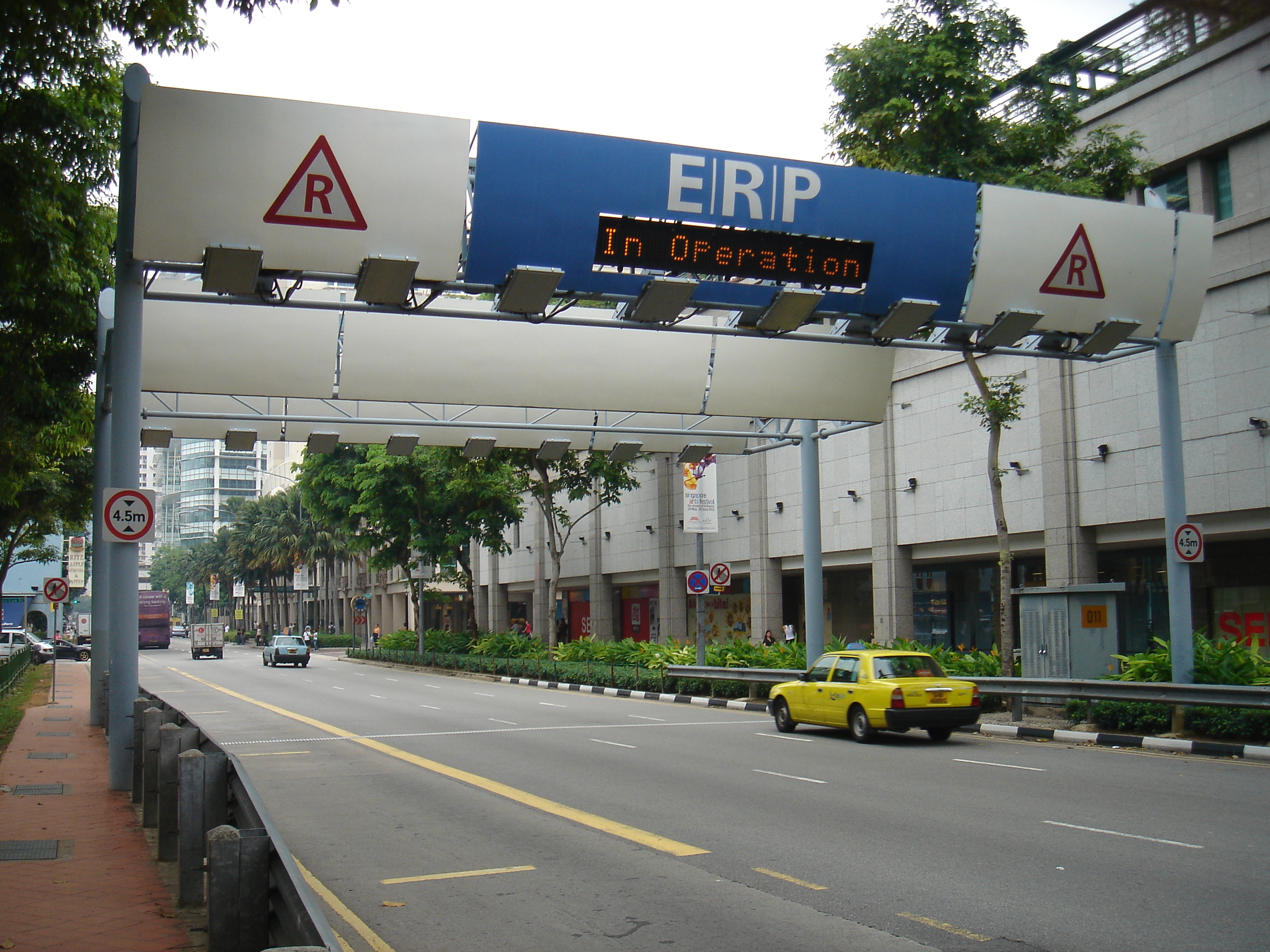
Singapore has long used what is now a rather dated tag and beacon system (DSRC) that is non-standard, and involves a two-way communication with vehicle on-board units (OBUs) by deducting prepaid credit from smart cards inserted into the OBUs.  To achieve the detection, the communication from the unit and back to the smart card (and provide back-up ANPR cameras for enforcement) has resulted in Singapore having very large elaborate gantries that many cities would see as unsightly (and which are increasingly controversial in Singapore itself).


Singapore ERP gantry

Thursday, 13 March 2014

Singapore confirming its shift to GNSS based urban road pricing

Singapore newspaper TODAY reports that the Singaporean government is going to replace the existing congestion pricing system (called ERP - Electronic Road Pricing) by 2020, implicitly with a GNSS based system that will allow more dynamic and variable pricing by individual road and time of day.

This follows trials that have occurred in the past few years, which included a number of prospective suppliers.

The report states:

The new system will allow the Government to calibrate the charging of motorists in proportion to the congested road segments that they use — “a fairer approach”, as Mrs Teo put it. It can also provide value-added services, such as navigation, payment for roadside parking in lieu of parking coupons and real-time traffic information.

It also explains a number of other measures to support car-sharing schemes, incentives to promote purchases of newer vehicles including discounts to the Certificates of Entitlement (permits to own motor vehicles) for those buying vehicles with the cleanest burning engines.

Whilst Singapore is different from many cities (not least being a city state, with a reputation for having quite strict laws), this move is significant.  

Singapore may be the first city in the world to introduce congestion pricing using GNSS technologies.   It will be able to set and vary charges on roads at little cost, and be able to be as flexible as it wishes in how it sets charges (and Singapore is already the world leader on this).  As such it is the holy grail of marginal road pricing, because it gets away from the need to install specialist equipment on every road, and means time and place based pricing can be implemented.

With six years to implement, Singapore has plenty of time to get it right.  What will be interesting is what other cities will follow, or if any dare to do so in advance of Singapore.

Meanwhile,  Senior Minister of State for Finance and Transport Josephine Teo insists that no new roads will be charged during the transition, and no new gantries will be introduced.  That's a relief, given the size of ERP gantries is enormous - partly due to the technology available at the time (1997) and because the system involves not just detection of a vehicle tag, but a read/write application to deduct funds from prepaid smartcards.  

Whilst some Singaporeans are concerned about privacy, I suspect others will be pleased to see the back of these gantries once the new system is in place.

Singapore ERP gantry

According to TODAY, tenders will be called in the coming months to develop and build the system.

A complete interactive map of all Singapore ERP gantries is available here, where you can click on each gantry, see its hours of operation and the different prices which in some cases vary on increments of five minutes.

Wednesday, 27 July 2011

More GNSS road pricing trials, but is much really learnt?

The European GNSS Agency (GSA) essentially exists to promote the EU’s competition for GPS, Galileo, by encouraging applications of GNSS (Global Navigation Satellite System) technology more generally. It funded a research project to identify how the road transport sector could use the technology, understandably it ended up with road pricing.

Inside GNSS reports on a project, called GINA (GNSS for Innovative road Applications – yes EU agencies aren’t great at acronyms, just Google GSA!) involved another (there have been many examples of this) set of field tests for the use of GNSS technology to charge for road use. Given the technology is used already in Switzerland, Germany, Slovakia and New Zealand to actually charge vehicles, you might wonder how much more is to be learned.

The project started in March 2009 and ended this year, with full details available on its website. The prime driver behind the project is listed as:

GINA proposes to address the existing obstacles preventing a large scale take-off of road pricing and other services (VAS) based on the use of EGNOS/Galileo by:
• Proving the technical feasibility and economical viability of a large scale, GNSS-only road pricing scheme (alternatives to GNSS are being considered by authorities)
• Fully identifying the potential benefits related to congestion and pollution management
• Demonstrating the possibility of VAS running on a road pricing operating platform, as well as the use of the same on board equipment shared by different applications
• Understanding the added value of the EU technology in terms of performance or cost improvement compared to GPS-only.

There are extensive newsletters and the like on the website, so I wont go into detail. However, it appears not to have been driven so much by policy makers, but by GNSS technicians. Take this point:

A particular focus is on protecting users against the incorrect charging that can sometimes arise from large position errors and service interruptions resulting from the use of a single unaugmented GNSS system, such as the current GPS or GLONASS civil services, which lack a built-in integrity capability.

It implies that anyone implementing road pricing would simply use GPS without any other form of measurement of distance or correlation to location (such as map matching). It is simply designed to prove how augmenting GPS will improve accuracy, which is a fait accompli. 

The summary result is that it came up with what it claims is an inexpensive on board unit that doesn’t need an on board map to measure distance. By response to that is “so what”? There already is one operating in New Zealand manufactured by a company called ERoad that does just that, with GPS.

The REAL benefit that comes from any form of GNSS based distance charging is being able to distinguish location and time of day anywhere in a network, that includes not charging for being off road. It means that roads can be priced accurately, everywhere.

The report here suggests that the trials would allow this, only by creating “geofences” as wide cordons, so that vehicles crossing certain co-ordinate defined points, could be charged differently.

My bigger question is whether there really is anything new learnt from any of this? The study was commissioned by a body with a vested interest in promoting Galileo and EGNOS, all very well. Certainly the greater accuracy Galileo and EGNOS can bring will be welcomed, but the issues with rolling out GNSS road pricing are not mainly around accuracy of signals. They are around:
- Logistics and costs of installing OBUs on large fleets;
- Public acceptability of OBUs, especially around privacy;
- Managing the unequipped user efficiently and effectively.

However, GSA doesn’t exist to deal with those issues, it only wants to prove GPS isn’t good enough – when, in fact, it has proven that it is.